weatheronline.co.uk
(Page 2 of 3)
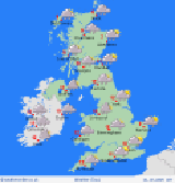 A frontal boundary drifts from the northwest to southeast brining
rain and wind to all areas through the day. Good morning, Those
on elevated terrain of northern England and Scotland will awake to
some morning ground frost. It's possible some local rural areas to
the south may see ground frosts as well under the clear overnight
and morning skies. The morning starts cloudy in Ireland and Scotland
as a frontal boundary soon arrives onto northwest coasts. Rain sets
in for several hours in Ireland and west Scotland, resolutely slipping
southeast through the day bringing a spell of rain to nearly all areas.
The heaviest of the rain is likely along the west coasts of southern
Scotland, England, and Wales. Southeast England stays driest longest
with patchy rain only arriving afternoon and setting in late in the
day. Rain will tend to break in Ireland and Scotland late in the day
through scattered showers will follow, particularly on northwest coasts.
High temperatures will reach 12
C in Ireland, nearer 8 to 10C in Britain. The large area of rain
will clear to the southeast overnight, but several frontal structures
are following in it's wake: expect heavy showers in Scotland and northern
England, these slowly trending southward overnight. Showers will continue
on west coasts as well with a risk of more patchy rain in southwest
England and southern Ireland. A few clear-sky spells are possible
but will likely be short lived. Low temperatures of 6 to 10C, for
most, though colder in central and north Scotland where more ground
frosts may form in the later hours.
A frontal boundary drifts from the northwest to southeast brining
rain and wind to all areas through the day. Good morning, Those
on elevated terrain of northern England and Scotland will awake to
some morning ground frost. It's possible some local rural areas to
the south may see ground frosts as well under the clear overnight
and morning skies. The morning starts cloudy in Ireland and Scotland
as a frontal boundary soon arrives onto northwest coasts. Rain sets
in for several hours in Ireland and west Scotland, resolutely slipping
southeast through the day bringing a spell of rain to nearly all areas.
The heaviest of the rain is likely along the west coasts of southern
Scotland, England, and Wales. Southeast England stays driest longest
with patchy rain only arriving afternoon and setting in late in the
day. Rain will tend to break in Ireland and Scotland late in the day
through scattered showers will follow, particularly on northwest coasts.
High temperatures will reach 12
C in Ireland, nearer 8 to 10C in Britain. The large area of rain
will clear to the southeast overnight, but several frontal structures
are following in it's wake: expect heavy showers in Scotland and northern
England, these slowly trending southward overnight. Showers will continue
on west coasts as well with a risk of more patchy rain in southwest
England and southern Ireland. A few clear-sky spells are possible
but will likely be short lived. Low temperatures of 6 to 10C, for
most, though colder in central and north Scotland where more ground
frosts may form in the later hours.
more...
------
back...
Main Menu
-----